
Alaska is a vast state and although most of it is roadless and inaccessible by vehicle the southcentral region of the state has an excellent highway system that allows access to many of the state’s premier National Parks and Refuges. There are several ways to get there, one could fly to Alaska and rent a vehicle when you arrive, take the AMH Ferry from Bellingham Washington up to Haines Alaska or drive up in your own vehicle on the Alcan Highway. But no matter how you get there a road trip in Alaska is a great way for anyone to see the spectacular natural beauty of the state and have an adventure of a lifetime!

After a delightful cruse up the mountain lined fjord of Lynn Canal Brenda and I arrived in Haines Alaska aboard the AMH Ferry Malaspina. We spent the night in Haines at the Victorian-era Hotel Halsingland before heading north on Haines Hwy 7 to the Canadian border. Passing by the spectacular mountains lining the Chilkat River Bald Eagle Preserve we stopped briefly at the Chilkat Indian Village of Klukwan before arriving at the Canadian border station. After passing through customs we continued north through the town of Haines Junction and on the Alcan Hwy 1 to make our first camp at Destruction Bay on Kluane Lake. Winter often stays late in the Yukon and even though it was the beginning of June the lake was still half frozen when we arrived.

We crossed back into Alaska and headed northwest on Alaska Hwy 2 stopping briefly for lunch at the Athabascan Indian village of Northway. On the road out of town we saw a rare sight even in Alaska a wolverine crossing the road in front of us. Solitary and secretive wolverines have a reputation for ferocity and strength out of proportion to its size and we considered our selves very lucky to have caught a glimpse of this powerful and elusive hunter. We camped for the night by the Tok River at the Tok River State Campground and the following morning had breakfast in the town of Tok Alaska that has the dubious distinction of being the coldest inhabited community in North America. Heading south on the Glenn Hwy 1 we stopped briefly to admire the colorful and artistic native grave houses at Mentasta Lake Village. A little ways farther we made a another detour down the Nabesna Road to explore and camp by the side of the rugged dirt road to enjoy a spectacular view of Mount Wrangle and the Saint Elias range. The next morning we returned to the Glenn Hwy 1 stopping at the town of Gakona to visit the Wrangell-St. Elias National Park Head Quarters before then turning onto the Richardson Hwy 4 and turning again onto the Edgerton Hwy 10 to finally arrive in the quaint little town of Chitna Alaska. We spent a good part of the afternoon there taking in the little shops and café before continuing on to find a campsite for the evening.

The 91mile (149 km) dirt road to McCarthy Alaska ends just short of its destination at the Kennicott River where a foot bridge allows pedestrian access into the town. The road is narrow and primitive and travelers would be well advised to inquire about its state of repair before attempting the drive. From the foot bridge it is an easy fifteen minute walk into town there you will find the historic McCarthy Lodge with rooms for rent and excellent food. If you go be sure to allow enough time to take in the town of McCarthy the and nearby town of Kennecott, two recently restored ghost towns that are rich with early Alaskan mining history. From the town of Kennicott Brenda and I hiked the 8 mile trail that parallels the huge Kennicott Glacier to a knoll overlooking the Stairway Icefall, a truly spectacular site. On the way back down the trail Brenda spotted a black bear crossing over the glacier from the other side and we wondered what would induce it to negotiate all those crevasses, how curious.

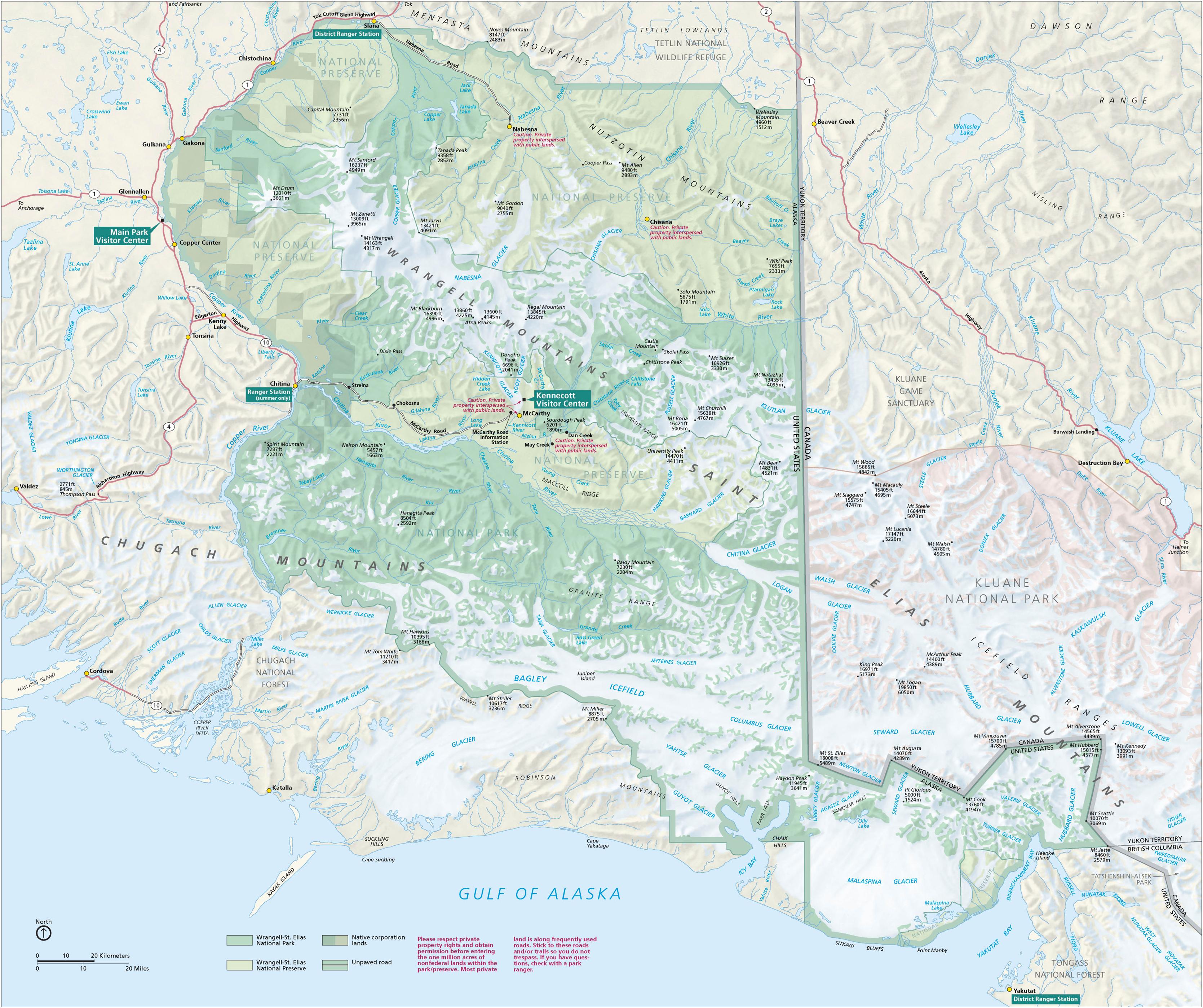
Wrangell-St. Elias National Park is located in the Southeastern region of Alaska and is bordered on the east by Canada's Kluane National Park. Encompassing 20,000 square miles of mountain wilderness it includes nine of the sixteen highest peaks in the US and has the largest concentration of mountains over 14,000 feet in North America. It is a land of uncommon beauty and because of its size and remoteness it is one of the least visited National Parks in the United States. The best way in to see and access the park is by air so Brenda and I met up with the folks at Wrangell Mountain Air to get an up close look at some of the giants of the range.

First on the list was Mount Wrangell at 14163 ft (4317m) it is a massive shield volcano and is the only volcano in the range to have had historically recorded eruptions, generally in the form of small steam and ash explosions. The amount of geothermal heat being emitted by Wrangell has been increasing since the 1950s, raising the possibility of a future eruption. In passing by the summit we could smell the strong odor of sulphurous gasses escaping from the 3.5 mile (5.6 km) wide caldera.

Next we circled around Mount Sanford that rises even higher at 16237 ft (4949m), and from there we crossed over the massive Nabesna Glacier at 75 mile (120 km) long it is one of North America’s largest and longest glaciers that is fed by approximately 40 other smaller tributary glaciers. Glad to have been in an airplane, it would have taken us weeks to traverse this area on foot!
 A few late morning clouds parted and we came face to face with mighty Mount Blackburn, at 16390 ft (4996) it is the highest peak in the Wrangell Mountains and is also the fifth highest peak in the United States. The western of Blackburn’s two summits is actually the mountain’s highest point however due to an early mapping error the eastern summit was originally thought to be its highest. The first ascent of this summit was made in 1912 via the Kennicott Glacier on the southeastern side of the mountain, and it should be noted that this was a substantial mountaineering accomplishment in its day, but the first ascent of the west peak and hence Mount Blackburn proper wasn’t climbed until 1958 by Gerry Roach and his team via the northwest ridge. After circling the lofty summit we descended down the broad Kennicott Glacier, passing over the area where we had camped earlier, to land at the small gravel airstrip by the town of McCarthy.


On the drive out from McCarthy we stopped for a hike at Liberty Falls, a short but steep scramble that leads to a beautiful view of the Tonsina River and the Wrangell Volcanoes. Our next stop was to observe the fisherman catching Sockeye Salmon along the Copper River, designated by Fish and Game as a personal use fishery where dip netting is the only allowable gear. At the town of Copper Center we stopped in at the Copper Center Museum to see the historic photos and interesting items from old time Alaska. Then it was on to the town of Glennallen and the Glenn Hwy 1 for a beautiful drive through the Chugach Mountains. There are several large glaciers that flow down towards the highway, the Tazlina the Nelchina and the Matanuska Glacier that comes almost down to the road. There are several good camping areas along this section of the highway before rolling into the town of Palmer and Alaska’s largest city Anchorage. After taking in the sights of the big city we headed south on Seward Hwy 1 towards the Kenai Peninsula and passed into Chugach State Park before arriving at the Portage Glacier. We drove into the Portage Glacier Visitor Center and from the information we received there we decided on hiking the Byron Glacier Trail, there at the base of the steep Byron Glacier on a sandy knoll we made camp for the night.


The Kenai Peninsula is often called Alaska’s Playground and for good reason, no matter what your favorite outdoor pastime is you will find it on the Kenai, all within an easy days drive from Anchorage. The Seward Hwy1 branches off and becomes the Sterling Hwy 1 that heads west following the Kenai River. We stopped along the way at tributary called the Russian River to do a little fishing at the state’s most popular sockeye salmon sports fishery. The fishing there is outstanding, for sure, but the area is crowded with both fisherman and bears and exemplifies the term “combat fishing”. We camped for the evening at Skilak Lake just off the highway that had a wonderful view of the surrounding mountains. The next morning we drove onto the town of Kenai to visit the Cultural Center and the historic Russian Orthodox Church before entering the Kenai National Wildlife Refuge. At the center of the refuge is Swanson River and Swan Lake Canoe Routes that connects dozens of lakes with short trail portages. If you plan to visit this part refuge in midsummer you might want to bring plenty of bug dope, arriving in early fall might be the better option. Heading south again on Sterling Hwy 1 we stopped in at the Norman Lowell Art Gallery and spent a wonderful afternoon admiring his paintings and quite frankly we were surprised to find such a magnificent collection and venue located in the wilds of Alaska. Towards the end of the day we finally arrived at the end of the road, Homer Alaska, and secured a campsite along the beach on the Homer Spit.


There is a lot to see and do in Homer Alaska located on beautiful Kachemak bay. There were numerous shops and restaurants to visit along the spit and we went see the interesting natural history exhibits at the Pratt Museum. Homer is also the jumping off point to explore the Alaskan Peninsula, Kodiak Island and the Aleutians. There are a number of air and ocean charter services located in Homer and it is also the port of call for the AMH ferry that runs out to Kodiak Island and the Aleutians. That evening we had to stop in for a beer at the rustic Salty Dog Saloon, an iconic Alaskan watering hole, before heading back to camp.

Returning back the way we came on Sterling Hwy 1we saw five moose by the side of the road, one was a good size bull with a full rack of antlers. We turned south on Seward Hwy 9 till we came to the little village of Moose Pass that was having their annual Summer Solstice party. There were live bands and fair booths to enjoy before we headed to the Carter Lake trail head nearby. The 3.5 miles (5.6 km) slog uphill to camp was well worth the effort to camp by this beautiful lake nestled in the high mountains. The fishing was good for trout in Carter Lake and Arctic Grayling in nearby Crescent Lake. When it came time to leave a rainbow appeared at the end of lake and we both thought it a shame to be leaving this magic place.

Rolling south on Seward Hwy 9 we passed the upper end of Kenai Lake on our way to the port city of Seward Alaska located at the end of Resurrection Bay. The port of Seward attracts a large volume of charter and cruise ships every summer and is the seventh most lucrative fisheries port in the US. Seward is also the terminus of the Alaska Railroad that runs all the way north to Anchorage and Fairbanks. The town boast Alaska’s premier public aquarium the Alaska Sea Life Center and is the gateway to Kenai Fjords National Park. For our camp that evening we drove just outside of town to the campground at the Exit Glacier. From the visitor center a moderate 1.5 mile (2.4 km) trail allows you to get close enough to climb up on top of the ice and peer into its deep crevasses.

Heading north on Seward Hwy 1 we stopped in for lunch at Alyeska Resort before hiking the Crow Pass Trail to camp overnight at Nancy Lake. The next morning we passed back through Anchorage and Palmer and drove up and over Hatcher Pass on the Fishhook Willow Road to visit the Independence Mine State Historical Park where gold was discovered in 1886. Heading north again on the George Parks Hwy 3 we came to the lively little town of Talkeetna that is the point of departure for mountaineering and air taxi services in Denali National Park. We spent the afternoon looking in the shops and enjoying the exhibits at the Ranger Station before stopping in for a cold one at the historic bucket of blood bar. The next day we drove on to Denali State Park and hiked up the Kesugi Ridge Trail and that evening we were treated to this breathtaking sunset over Mount McKinley and the Alaska Range.

Late that night a strong wind came up and blew away the clouds and almost blew us and our tent away as well! In the dark we scrambled to relocate it behind a large boulder for protection. When the sun came up the next morning the sky was clear and we could see the summit of McKinley shining on the horizon. We spent the day exploring the small lakes and alpine tundra on top of Kesugi Ridge before heading down to continue our journey. Past the town of Cantwell Alaska we turned right onto the Denali Hwy 8, a well graded two lane dirt road that traverses along the southern slopes of the Alaskan Range. After several miles we stopped at Tangle Lakes to make camp and get in a little fishing, when the wind wasn’t blowing the misquotes were out but the great fishing for Lake Trout and Arctic Grayling made it all worthwhile.

At the end of the Denali Hwy 8 we came to the little town of Paxson Alaska where we turned north onto the Richardson Hwy 4. Just up the road we found a camp site at the Castner Glacier across from the wild and scenic Delta River. The next morning after going for a short hike up the boulder strewn moraine to the toe of the glacier we continued driving north to arrive at the town of Delta Junction Alaska. Just outside of town we saw a curious sight, a large heard of Bison roaming the countryside. It turned out to be a private game farm, around sixteen thousand hunters apply each year for the chance to hunt these massive beasts but only about one hundred and twenty people had received permits that year. From Delta Junction we continued southeast on the Alaska Hwy 2 that follows the Tanana River Valley eventually arriving at the Tetlin National Wildlife Refuge. A vast wetland the refuge is host to one hundred and ninety species of birds and there were blinds provided by the refuge along Tanana River and adjacent lakes for their viewing.

After enjoying the birds of the refuge we headed southeast again to the Yukon border. We passed through the little town of Beaver Creek before stopping for the night at the lodge at Burwash Landing on Kluane Lake. While we were there we enjoyed the exhibits at the Kluane Museum of Natural History that offers a wildlife exhibit along with displays on history and culture the Southern Tutchone people. The next day we drove into the town of Haines Junction and stopped at the park headquarters for the Kluane National Park, there we enjoyed looking at the exhibits, chatted with the staff, inquired about local air taxi service and bought maps for future trips to the area. Then it was off again to the Alaska border and into the town of Haines to wait for the ferry to arrive. As we waited for our ride home we reflected on our amazing journey of three thousand one hundred and eighty three miles and we felt as if we had just begun to explore our vast and magnificent state, Alaska the last frontier.

If you are planning a road trip to Alaska of your own we would like to suggest two guide books that we found very helpful to us along the way. The De LORME Alaska Atlas and Gazetteer is a wonderful road and topographic map covering the entire state and The Milepost a legendary trip planner and travel guide to the highways, roads, ferries, lodgings, recreation, sightseeing attractions and services in Alaska, the Yukon and British Columbia.