
Ketchikan Alaska, Population 8,050, located
on Revillagigedo Island in the southern end of Alaska’s panhandle is often the visitor’s
first stop in Alaska when traveling on the Alaska Ferry System north through
the Inside Passage. Its name comes from the areas first inhabitance the Taant’a Ḵwáan of the Tlingit Nation who named
the salmon rich creek that runs through town Kichx'áan” meaning thundering wings of an eagle.
Today the bountiful salmon that run up the creek are still a strong part of the
local economy along with tourism, shipbuilding and lumber. The area is on
average much wetter than most parts of the state with an average of 153 inches
of rain yearly, but surprisingly it rained very little during my June visit to
hike their extensive trail system.

From the ferry dock I meandered up
through Ketchikan’s West End neighborhood to the start of the Carlanna Lake
Trail. This easy 1.5 mile trail along the east side of the lake passed by
several fishing platforms and a splendid old growth forest full of enormous
Spruce and Red Cedar trees. The well graveled trail ended abruptly at the end
of an avalanche chute where the Mount Minerva ridge traverse began. The 6.5
mile route over Mount Minerva was primitive though well brushed and flagged,
strong legs were needed and expert route finding skills were a must as the
upper section of trail along the ridge was often in thick clouds and whiteout
conditions were the norm. Once past the summits of Mount Juno (2600 ft) and
Ward Mountain (2670ft) the grade eased and become a long gentle slope down to
the board walk trail around Perseverance Lake.

At the north end of Perseverance Lake elevated
tent platforms offered a fine view of the lake and the Mount Minerva ridge. I
camped there and enjoyed a fresh breeze off the lake that kept the flying
insects at bay. The following day I continued down the 2.4 mile board walk
trail through a forest of large trees and luxuriant
foliage to trails end.

Upon arriving at the end of the
Perseverance Lake Trail my age was starting to catch up with me so instead of
continuing on I decided to spring for a paid camp site. Surrounded by large
trees and a full view of Ward Lake the Signal Creek Campground connected to
several other trails that continued up into the heavily forested valley. On the
weekends the area around Ward Lake can be heavily used but during the weekday
when I was there it was calm and serine. After dinner I went for a leisurely
1.3 mile stroll around the Ward Lake Trail to enjoy the surrounding scenery and
the shade of its ancient forest.

After a restful night sleep I hiked up
the valley on the 2.5 mile Ward Creek Trail and stopped briefly at several of
the viewing platforms along the way to admire the cascading river below. At
trails end there was a short stretch of gravel road that connected to the
Connell Lake Trail. This 2.1 mile forested trail meanders along the west side
of Connell Lake, parallels a short connecting stream and ends at a tent
platform on the south shore of Talbot Lake. These two lakes were favored by
local fisherman and a Common Loon that hung out by my camp and showed us how
catching fish was really done.

After retracing my steps back out the
Connell Lake Trail and continuing downstream via the 2.5 mile Pipeline Trail I
emerged back in civilization at Ward Cove on the North Tongass Highway. After a
short wait I boarded the city bus that took me to Downtown Ketchikan and got
off by this unusual eagle totem that was carved, as I was to find out latter,
by renowned local artist Nathan Jackson.
From there it was a short walk across the street to the historic Gilmore Hotel to book a room for the night, get a good meal and a long awaited hot
shower.

This being my first trip to Ketchikan I wanted to see as much of the
town as I could during my all too brief stay. Creek Street an iconic neighborhood
that today features many unique hotels restaurants and art galleries was at one
time the city’s red light district. Strolling along the boardwalk I watched old
timers fishing from the bridge, kids swimming in the creek below and wandered
into the gallery of artist Ray Troll whose work I have admired for years. Ray’s
humorous and often surreal imagery captures perfectly the Northwest’s fishing
culture and his curious love of paleoichthyology (the study of prehistoric
fish). At the end of the street was The Married Mans Trail a short but
lovely forested walk that, back in the day, provided the towns “upstanding
citizens” access to the brothels and speakeasies without the embarrassment of being
seen.

During the summer months Ketchikan receives just over a million visitors
annually, the vast majority of whom arrive by cruise ship that tie up to the
downtown docks. Downtown merchants do a brisk business when the ships are in
but generally close up after the ships depart in the afternoon. The few
businesses that remain open are there to serve local needs such as the
independent book store Parnassus Books located on Stedman Street. I stopped in
briefly to peruse their shelves and found an abundance of worthwhile books and
information on early Ketchikan and Alaskan history. Once the crowds of tourist
were gone for the day I walked the waterfront promenade to enjoy its maritime
view and paused to admire this sculpture that celebrates the city’s early
inhabitance and its rugged pioneers.

After purging my backpack of all unnecessary weight I began my final trek to the summit of Deer Mountain. The 2.75 mile Deer Mountain Trail rises 3001 feet from sea level and climbs steeply with many switchbacks. There were two viewpoints along this well maintained trail that made for welcomed rest stops. The view from the summit was well worth the effort though as mountains, islands and fjords stretch out in all directions. Directly below me the city of Ketchikan shone in the midday sun as the faint sounds of civilization echoed up from below.

I had originally intended to make the 13.75 mile ridge traverse from Deer Mountain across to Northbird Peak and out the Silvis Lakes Trail but the lingering snow pack made the crossing unadvisable. Without the proper mountaineering gear surmounting those steep and icy snowfields would have been treacherous. Instead I chose to spend the two days I had allotted for the ridge to just camping out near the summit of Deer Mountain and enjoying the magnificent alpine vistas.

After hiking back down the mountain my goal was to explore as many of the cultural treasures of the area as was possible before the ferry arrived for my return voyage home. To that end my first stop was the City of Ketchikan’s Totem Heritage Center located on Deermount Street. The center was established originally to preserve endangered 19th century totem poles retrieved, with the consent of surviving tribal members, from uninhabited Tlingit and Haida villages near Ketchikan. Those original poles were displayed inside the building that is also used to promote Tlingit, Haida, and Tsimshian traditional arts through a nationally recognized program of native arts classes.

The Saxman Totem Park and Tribal House was located just 3 miles down the
South Tongass Highway from Ketchikan and had a spectacular collection of
Tlingit totem poles in a beautiful park like setting. The native village of Saxman
(population 415) was founded in the late 19th century when residents of the
traditional Tlingit villages of Cape Fox and Tongass decided to consolidate
their communities on Revillagigedo Island. Guided tours of the Tribal House
with traditional music and dance were available throughout the summer months.

Traditionally totem poles were carved
to honor important individuals, commemorate significant events and to proclaim
the lineage and social standing of their owners. They are visual references to
the people, events and legends that figure in the oral histories of northwest
coast native peoples and as such have significant cultural importance. But it
is important to note however that they were not religious objects and were
never worshiped. This totem pole illustrates three stories surrounding the
adventures and misadventures of the cultural hero Raven located at the top of
the pole with outstretched wings. To learn more about the totem poles of the
Ketchikan area you may wish to read, The Wolf and the Raven: Totem Poles of Southeastern Alaska by Viola E. Garfield and Linn A. Forrest.

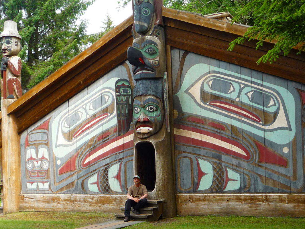
My last stop was to Totem Bight State Park
located about 10 miles out of town on the North Tongass Highway. This beautiful
park contains fourteen poles along a forested trail along with this authentic
reproduction of a traditional Clan House. Inside is one large room with a
central fireplace surrounded by a planked platform. This kind of dwelling
served as living quarters for several families of a particular lineage. Each
was allotted its own space but shared a common fire. Personal possessions were
stored in cedar boxes and under removable floor boards. Food items were hung
from the beams and rafters. The members belonging to the house would be headed
by a house chief of the same lineage. Today modern houses have replaced the
Clan House, skiffs and motorboats have replaced canoes, but the Tlingit people’s
deep connection to their land, culture and family continues, now and into the
future.
“A people without the knowledge of
their past history, origin and culture is like a tree without roots” - MarcusGarvey